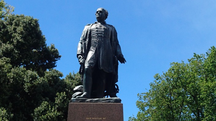
From my cubicle at work I can see a city square. At the centre of that tree-lined public park there stands a statue, the likeness of a notable local: former governor of the realm, Sir John Franklin, best remembered for his attempt to find a link between the world’s two largest oceans.
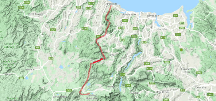
A northwest passage – Franklin is not the only Tasmanian to seek one out. In March I embarked upon a perilous quest of my own: a solo walk that took me from the top end of the island to the edge of its spiritual heartland; a 100 kilometre hike I hoped would help me find a way through my worries, through the fears and frustrations hemming me in.
Franklin’s journal is lost. Mine, though, lives on to tell the following tale, one of danger, daring and discomfort, of sights and insights, of isolation, liberation and elation.
PROLOGUE: Sunday, 3 March 2019 – Hobart to Penguin (300 km by bus)
It’s eight-thirty and I’m sitting in my tent at the caravan park, gazing out at the hazy waters of Bass Strait.
Today a bus brought me to Penguin, weeks of frantic preparation at an end. I sat beside a big bloke from the mainland, here to manage the merger of two minor banks; he dozed on my shoulder most of the way. I distracted myself by listening to Jeremy Irons read Lolita, hoping he wouldn’t be overheard.
As we drove through Deloraine a man in a pub raised his beer to the bus – an acknowledgement of my boldness, I fancied. Later, the driver dropped me at the park and I settled in.
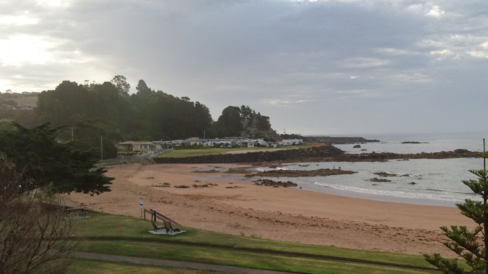
Penguin Caravan Park
I ate dinner at a café in town – a tasty pumpkin and walnut salad complemented by truffle-clad chips and a beer – while watching a musician play. During ‘Ring of Fire’ I thought I saw Johnny Cash cross the street.
Thrilled with the experience, I wandered back to the caravan park, where a dip in the ocean ended the day. Tomorrow I step off into the unknown. My passage – to what? – has begun.
DAY 1: Monday, 4 March 2019 – Penguin to Hardstaff Creek (29 km on foot)
What a day! Perhaps I pushed myself a little too hard…
Skipping breakfast, I got away early, said goodbye to the caravan park and strode purposefully through Penguin, perversely pleased at having a heavy pack on my back once again.
The day was cloudless, sunny and still, and I arrived at the start of the trail feeling anxious but excited. Stopping for a snack and a selfie, I tightened the waist belt of my pack and stepped on to the track. The moment had arrived!
One happy camper at the start of the track
Having finally made it to the trail, I didn’t stay there for long, diverting early so as to take in Mount Gnomon, a friend’s favourite peak. I stopped for tea and porridge on the way, at the top of Mount Dial.
On Gnomon I made a fateful decision: to head up Mount Duncan, via the Tall Tree Track, rather than rejoin the main trail. Thus I added ten kilometres to the journey, all of them hard going.
Mount Duncan, however, was worth the toil: the view was magnificent. From the peak I could see the Nut at Stanley in the north and Cradle Mountain in the south, and a pretty patchwork of farmland in between.
The view from Mount Duncan to the north-east
As I munched on mountain bread, salami and cheese, a lone eagle rode the eddies below, soaring up to hang motionless in the air above. A nearby mobile phone tower hummed melodiously in the wind.
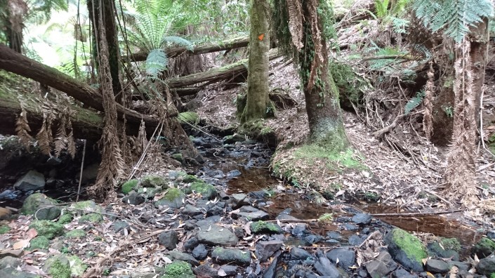
It was all downhill from there. Several hours later I rejoined the main track, which met up again with the Leven River, not far from the campsite at Hardstaff Creek. There I made camp.
Fighting exhaustion, I collected water and cooked up a tasty stew. After reading (Clive James’ Unreliable Memoirs on my Kindle) and writing (in my diary) I slept, soothed by a sense of relief – I’d survived the first day! – and the rushing river nearby.
DAY 2: Tuesday, 5 March 2019 – Hardstaff Creek to Dobsons Flats (25 km)
So ends an eventful day! Despite vowing not to repeat the excesses of yesterday, I did just that.
The first crisis came early, when I realised I’d strained a muscle above my right knee. Not severely, mind you, but badly enough to make walking downhill a real pain. I strapped up my thigh and struggled on.
The first few hours (up Mount Lorymer and along the Dial Range) were tough: the track was overgrown, steep in places and slippery with snakes.
Yes, SNAKES! Two dark little things that darted away before any damage was done. Shaken, I kept my eyes on the track for most of the morning.
Gotcha!: A track marker somewhere on Mount Lorymer
Descending through a plantation of pines, I limped into Wings Wildlife Park, where the trail notes suggested staying the night. It was early afternoon and I had a decision to make. Give in to the pain and hole up at Wings awaiting collection? Or push through it and carry on?
Knowing that the hardest part of the walk was yet to come, I decided to soldier on – but only if I could get ahead by finishing the next leg – a twelve kilometre ramble along country lanes – today.
Decision made, I answered the call of nature – good timing that! – and refilled my water bottles from a rainwater tank. I saddled myself up and was on the road by three o’clock.
The next two-and-a-half hours went like a dream. The weather was still and warm, and the road was mine; my pack sat snugly on my back and my leg felt fine.
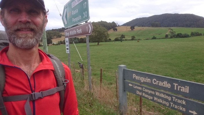
Setting out on the ‘country lane leg’ of the walk
As I passed through the paddocks I was watched by beefy black cows, inquisitive yet timid. Tiny amber crickets clicked and clacked at my feet, leaping about like jack-in-the-boxes.
The air was rich with the aroma of hay, big round bales of which stood in long lines, looking like great wheels of cheese. I almost envied the cows.
Some things were not so benign.
Tempted by the blackberries growing alongside the road, I asked a woman at a farmhouse if the bushes in the area had been sprayed. She pointed to a patch. ‘They’re okay to eat.’ As I tucked in her husband drove up. ‘I wouldn’t do that,’ he said. ‘I sprayed them yesterday.’ ‘Give my regards to your missus,’ I called after him. (Or wanted to.)
As I neared my next campsite, at Dobsons Flats, I stopped for a wash in the River Leven, my first for the trip. Boy, did I need that bath!
My campsite at Dobsons Flats (unmade)
In the twilight I put up my tent and ate a meal, looking out over the river. Another big day awaits me tomorrow. As hard as it will be, though, I know there’s no going back.
With kookaburras chuckling, waters warbling and rain spattering on the tent, I head for bed.
DAY 3: Wednesday, 6 March 2019 – Dobsons Flats to Leven Canyon (15 km)
Crazy day today! By trying to make it easier for myself I somehow made it harder.
The bad news is that the weather turned wet, and I sat out two heavy showers of rain. The good news is that I nearly died only twice and that I got lost only thrice.
Ultimately, though, I pushed myself to the limit and my body responded; my leg now feels better than it did, despite the punishment I put it through. Go figure!
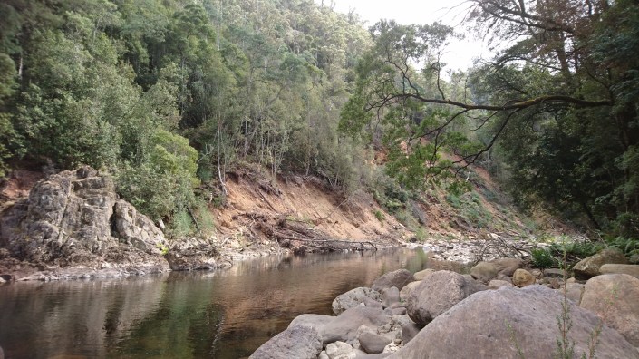
The track was amazing but atrocious: a narrow crumbling ledge carved out of the hillside above the River Leven. My near-death experiences came where the path had fallen away, and where I almost fell away too. They passed quickly.
Worse were the times I lost the track, because they took longer. In two places the trail descends to the river – the first to skirt a landfall, the second by design – and in both places I had trouble relocating the track.
The bit of the river bank where the track had fallen away
The first descent happened about halfway along. Relying on intuition and imaginative reading of the trail notes, I guessed I had to rock-hop across the river, work my way up the opposite bank, then rock-hop back. Having done so, though, I couldn’t find where the track recommenced. My panic grew during the hour it took me to stumble on the opening.
Then there was the rope used by walkers to haul themselves up a steep bit of bank. I just couldn’t find it! After a desperate search I eventually spotted it in the distance.
The track: made for mountain goats
The delays were disruptive. I’d planned to push on and camp near Griffiths Flats, but I now had barely two hours to do the most demanding part of the walk: the ascent of Leven Canyon, in fading light.
Running on adrenaline and anxious energy, I struck out. It was terrifying stuff, since the track petered out well below the summit.
Luck was with me: falling and floundering, my pack dragging me down, I happened to see light through the trees, a break in the buttress of rock. Making one desperate last effort, I scrambled straight up and – lo and behold! – found myself back on the track. It felt like a minor miracle.
From there it was a short walk to the top, where I pitched my tent (with difficulty) in a fortuitous flat open space. And here I am, shivering in my sleeping bag despite donning all my clothes, trying not to slip away down the slope.
All in all, it was an amazing day. One smell has stayed with me: a fecund pong, probably that of rotting leaves, sour but not repulsive. A healthy kind of yuck – just like this walk!
The view the next morning from the top of Leven Canyon
DAY 4: Thursday, 7 March 2019 – Leven Canyon to Paddys Lake (15 km)
This day is described as the hardest of the walk and boy did it live up to the billing!
Despite the difficulty I made it to my campsite just after four (it’s now almost six), which is nice for a change. I’m all set up now, my tent angling into the wind – of which there can be plenty at these sub-alpine heights. (It’s fairly calm right now.)
I had a chilly old time last night. Although I kept riding my mattress to the bottom of the tent, I managed to get some rest.
I got off to a frustrating start in the morning, wasting time and energy trying to find the way down the hillside, only to discover it right under my nose. I’m learning that some things on the map can be trusted, and that the trick is knowing what they are.
The canyon itself is impressive. The track down its side was rocky and steep; it was followed by a leg through ferny groves and an indecently easy stretch along a dirt road.
Looking back at Leven Canyon
The adrenaline I’ve been riding ran out at midday, near Taylors Flats, at the start of an ‘unrelenting’ ascent that took me three hours. Rarely have I been happier to reach the end of a leg.
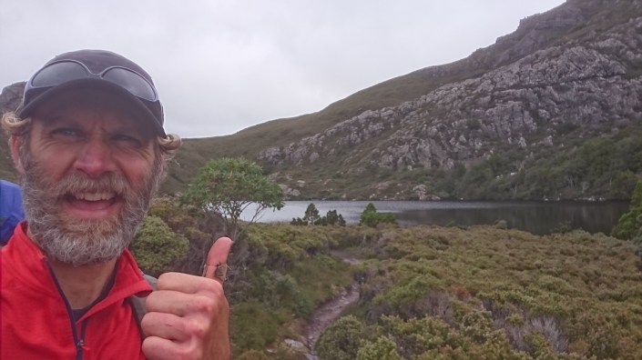
And now here I am, in the high country, parked beside a beautiful tarn.
My joyful arrival at Paddys Lake
As I was leaving the canyon I ran into an unfamiliar animal (i.e. a person): Phil from Melbourne, who’d come from camping at the Walls of Jerusalem.
Phil had hoped to walk the trail but he’d picked up an infection from a blister, so he was doing day walks instead. It was nice to have a natter.
Before we parted Phil asked if I’d lost a slip of paper, because he’d found one back on the track. Oddly enough, I had. He handed over the page on which I’d scribbled my plans. I’d hardly missed it.
Gee, I’m getting hungry as I write this, having not had dinner yet. Tonight’s main course is miso soup with fresh carrots and onion, dried peas and dried mushrooms. The tucker’s pretty good out here!
Oh, and I’m into my fourth near-death experience of the trip: there’s a tick on my leg, sucking out my life blood. I’ve smothered the bugger in lip balm having doused it with metho, so perhaps I’ll pull through.
After pitching my tent I tried to climb Black Bluff, the big rocky outcrop that towers over the lake, but was forced back down when the clouds closed in. Bummer! The views up there are to die for (which I wasn’t willing to).
An early night tonight, then, ahead of a another big day tomorrow.
DAY 5: Friday, 8 March 2019 – Paddys Lake to Fourways (25 km)
I’m just about done for the day, thankfully!
This leg posed a different kind of challenge: it was all about dealing with monotony and discomfort rather than solving navigational puzzles or staying alive. I’m happy to say that I passed the test.
I woke early in an attempt to have a second go at getting up the bluff, but the weather was worse than yesterday, serving up rain and wind and fog. It did mean, however, that I was able to get away by seven, which worked in my favour later on, when I got to have a peek at a different peak.
For much of the day I froze. This part of the trail is exposed to the elements and the winds were wild. The track itself was testing: a narrow groove overgrown with low heathy plants sporting sharp little leaves.
Stubbornly unwilling to change out of my shorts, I blundered on, my shins getting lacerated, my socks and boots saturated. Now I know why hikers wear gaiters!
The atmosphere was eerie, almost alien, there being so few signs of life (as I know it). Even I was barely alive! Later on I was joined by green parrots and felt less alone.
Looking south along Black Bluff Range
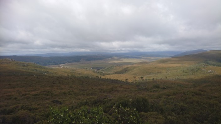
Slope after slope after slope – the monotony was driving me mad. The weather only made things worse, low scudding clouds obscuring the expansive views.
I had morning tea (couscous and a coffee) huddled behind a rock, Cradle Mountain occasionally visible in the distance.
It was around then that my leg began to play up again, which at least gave me something to think about. I limped on and gradually got below the worst of the wind, the Vale of Belvoir spread out below on my left.
Cradle Mountain comes into view over the Vale of Belvoir
I lunched at the foot of a lookout where the road runs past. Here I met David and Janice from Canada, who are tooling – nay, touring – around Tasmania on bikes. What a nice couple they were, Janice offering me chocolate when she heard I’d walked all the way from the coast.
I got my second wind after that (thanks, perhaps, to the cheese I’d eaten, sadly the last of my supply) and charged on, my leg aching less.
At three o’clock I reached a junction in the track where a side trail leads up to Mount Beecroft. Determined not to miss out on a second peak in one day, I shed my pack, threw a few things in a shoulder bag and shimmied up the slope.
I ate my last biscuit at the summit and admired the panoramic view, feeling on top of the world.
From there it was a painful hour-long descent to the Fourways campsite, where I now recline, at the junction of four chattering creeks. With only a few hours of walking left on the trail tomorrow, it’s starting to look like I might make it after all.
DAY 6: Saturday, 9 March 2019 – Fourways to Cradle Mountain Visitor Centre (10 km)
I woke early this morning as I did not want to miss my connection (the bus to Launceston, leaving from the Cradle Mountain Visitor Centre at midday).
The last leg of the trail was no easier than the rest, with much of the track being boggy and rough. The weather, too, was unchanged: overcast and cold. To my dismay, thick banks of clouds obscured Cradle Mountain as I laboured towards it.
V for Victory: Somewhere near Pandani Grove
The first few kilometres of the track wound its way through a myrtle forest, and here I had to contend with ‘killer’ leeches, which descended on me in droves. Very tasty (me, that is, not them). ‘Gaiter aid’ would have been very welcome.
To make matters worse, there was no brass band to greet me as I emerged from the wilds, just a bemused German tourist who gave me vague German directions to the visitor centre.
Ah, the visitor centre! Instead of being conveniently situated at the end of the trail, the building is two kilometres away, up a long steady slope. This discovery might have broken a lesser man’s spirit but I took it in my stride – over two thousand of them, in fact.
I arrived at the centre with an hour to spare. My relief was enormous: I hadn’t missed the bus and, oh yeah, I’d walked the trail! I then devoured two of the tastiest sausage rolls I’ll ever eat.
Momentarily replete, I repaired to a restroom, where I cleaned myself up, exchanging my wet and dirties for the dry clothes I’d had hiding in my pack. I also mopped the mud and blood off my lower legs, albeit with some sadness: the mess on my shins was a kind of biological record of my journey, bearing witness to the places I’d been.
Then it was back to the café for banana bread and coffee while I waited for my ride. And who should be seated at the table beside me, sheltering from the streams of Asian and European tourists?
Why, David and Janice, of course, the cyclists I’d met yesterday. We greeted each other like long-lost friends. (Had they given me up as dead?) As it happened, Janice had something to tell me. ‘I was exhausted when we met,’ she said, ‘but you inspired me to go on.’
I joined them at their table and we chattered away like children.
They told me about a time they’d been hiking in Canada with some kids and got caught out in the snow. While the youngsters sweated it up with a camp oven in the canvas tent, they’d spent a sleepless night huddled together on a wagon.
We flippantly agreed that there should be a badge for hardy adventurers like us, one that would reveal what we really are (i.e. hardy adventurers). David told me not to worry: he said he could see my stamp.
With that we parted and I raced for the bus, hoping my stamp would stay with me and that I would always have the eyes to see it.
EPILOGUE: Saturday, 9 March 2019 – Cradle Mountain Visitor Centre to Launceston (150 km by bus)
Civilisation tried to reassert itself over the airwaves as we wound our way cityward. Dave, the driver, had (optimistically) turned on the radio and static played softly in the background for most of the trip.
As we entered Launceston, though, Frankie (Goes to Hollywood) broke through, telling me to relax, don’t do it. But it was too late by then – I had returned to the real world.
I had a great chat with Dave on the journey, bare feet and all. (My boots were wet!) So many people, so many stories. I was the only passenger on the bus and, as I learned, the last one ever, since the service was ending.
Dave was a friendly, down-to-earth bloke; born in Deloraine, he’d been driving trucks and buses in northern Tasmania for close on thirty years. He’d camped in the area back when he was a kid, so I fancied he could see my badge as he glanced back at me.
Later I sat back and savoured my emotions: the pride and satisfaction I felt, the tranquility, hopefulness and sense of resolve. Out there I’d learned to trust myself, and I’d come to realise that I’m capable of more than I think. Yes, I’d had doubts and concerns – almost constantly – but they’d been rooted in reality rather than mostly imagined, as my usual worries are. There’s a lesson in that, I’m sure.
As I watched the last of the wilderness whipping by, I reflected on how I’d felt at home in the bush, even though I was always aware of the dangers. I’d been at one with myself and the world, and this had informed my interactions with the people I’d met: Phil, David and Janice, and Dave the driver, who even now was piloting the bus into the transit centre.
Would my trek from coast to Cradle Mountain prove to be a kind of rebirth, I wondered, a second coming of sorts? Only time will tell.
Before my expedition I saw John Franklin as a flinty faraway figure. Now, though, as I sit in the square across the street from my office, I feel a kinship with the man in the monument. And why not? The quest for a northwest passage altered both of our lives – Franklin’s for the worse but mine, I hope, for the better.
Equipment: backpack and pack cover; tent; inflatable mattress; water filter; Trangia, fuel and fuel bottle; first aid kit; personal locator beacon, folding shovel and toilet paper; head torch and batteries; cord, compass and whistle; journal and maps; mobile phone, batteries and cable; Kindle and cover; water bottles (2); knife and cutting board; spoon and cup; rain jacket, fleece jacket and shirts (2); long pants; thermal underwear; socks (3 pairs); gloves and cap; sunglasses and sunscreen; food and water (Total weight: 17 kg)
Food: leaf tea and porridge (oats, dried cranberries and pepitas); instant decaf coffee, home-baked biscuits and mixed raw nuts; couscous mix (including raisins, pine nuts and spices) and dried apricots; salami, cheese, mountain bread and chocolate; dried figs; soy mince, fresh carrot and onion, dried peas and herbs; miso, dried mushrooms and peas, fresh carrot and onion; red lentils, fresh carrot and onion, dried peas and curry paste (Breakfast, morning tea, brunch, lunch, afternoon tea, dinner and supper)
Not sure if I’m ready to tackle the whole journey yet (sounds too much like hard work!), but it’s right on my doorstep and I’ve been knocking off one section at a time solo, very helpful to have this trip report as a bit of a guide, great read too. Cheers mate 🙂
This is a beautiful story of courage, resilience and bravery in times of trouble. I also did the paddy’s lake part of the walk 3 years later with the man himself. I was very grateful to be in his presence I felt I was very humbled by this great man.


December 11, 2019 at 8:54 pm
Well done son but mum says next time go with a walking group.
December 23, 2019 at 7:45 am
Wow Timm, just sat down to have a read. What an amazing achievement! Very proud of you!
August 26, 2020 at 9:59 am
Awesome story, very helpful and interesting report. Thanks mate. Well done.
August 26, 2020 at 10:13 am
Cheers, Brad – thanks. Sounds like you might be preparing for the walk. If so, enjoy – it’s a ripper!
August 30, 2020 at 6:26 pm
Not sure if I’m ready to tackle the whole journey yet (sounds too much like hard work!), but it’s right on my doorstep and I’ve been knocking off one section at a time solo, very helpful to have this trip report as a bit of a guide, great read too. Cheers mate 🙂
March 19, 2023 at 9:56 am
This is a beautiful story of courage, resilience and bravery in times of trouble. I also did the paddy’s lake part of the walk 3 years later with the man himself. I was very grateful to be in his presence I felt I was very humbled by this great man.